Rome - Via Appia Antica
Interactive map
GPS track profile
About this GPS track
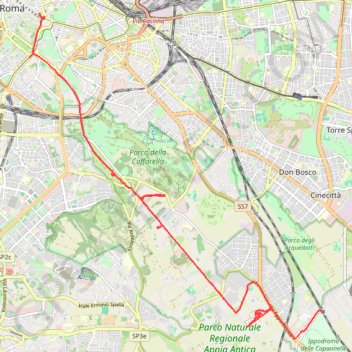
Name: Rome - Via Appia Antica GPS track, route, trail
Coordinates: 41.82515 12.48793 41.89225 12.56888
Other GPS tracks
Click on a GPS track to view route, its statistics and profile.
1 LUCENA - MONTPELLIER
Distance: 2,964.4 Km • Elevation gain: 29,500 m • Maximum elevation: 1,048 m
1 LUCENA - MONTPELLIER
Espagne > Andalousie > Lucena
Distance: 2,964.4 Km • Elevation gain: 29,500 m • Maximum elevation: 1,048 m
Percorso selezionato
Italie > Lombardie > Côme > Côme
Percorso calcolato con http://www.bicitalia.org/it/routing-gpx
Distance: 1,543.9 Km • Elevation gain: 17,951 m • Maximum elevation: 1,034 m
Rome, Colisée, Palatin, forums
Italie > Latium > Roma Capitale > Rome
Randonnée en aller-retour depuis Roma. #Randonnée
Distance: 10.0 Km • Elevation gain: 185 m • Maximum elevation: 53 m
Rome, quartier EUR et Trastevere
Italie > Latium > Roma Capitale > Rome
Randonnée pédestre. Depuis Roma. #Randonnée
Distance: 20.7 Km • Elevation gain: 327 m • Maximum elevation: 90 m