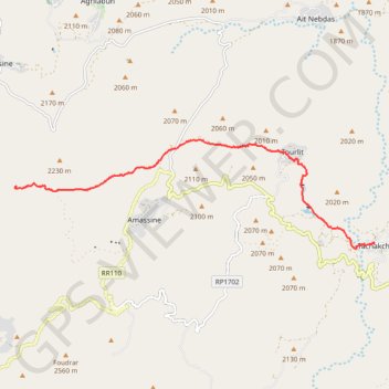
Rando Maroc
Randonnée depuis Tachokchte. #Randonnée
- Distance: 11.9 Km
- Elevation gain: 542 m
- Maximum elevation: 2,214 m
- Elevation loss: 281 m
- Minimum elevation: 1,866 m
- Moving time: 3 h 41 m
- Moving speed: 3.2 Km/h
- Maximum speed: 40.1 Km/h
- Total time: 4 h 37 m
- Global speed: 2.6 Km/h
- Date: 05/05/2015
Interactive map
GPS track profile
About this GPS track
Name: Rando Maroc GPS track, route, trail
Coordinates: 30.80242 -7.61609 30.82616 -7.52477
Other GPS tracks
Click on a GPS track to view route, its statistics and profile.
Maroc en boucle depuis Tanger
Maroc > pachalik de Tanger > Tanger
Distance: 3,028.7 Km • Elevation gain: 27,253 m • Maximum elevation: 2,301 m
Marruecos Junio 2019. De Berguent a Esmara
Maroc > Pachalik de Ain Bni Mathar > Ain Bni Mathar
Distance: 2,271.6 Km • Elevation gain: 11,817 m • Maximum elevation: 1,454 m
Maroc 2018
Depuis Marrakech.
Distance: 1,653.8 Km • Elevation gain: 13,346 m • Maximum elevation: 2,213 m