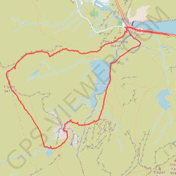
Llyn Ogwyn, Devil's Kitchen and Y Garn circuit
- Distance: 9.2 Km
- Elevation gain: 743 m
- Maximum elevation: 932 m
- Elevation loss: 744 m
- Minimum elevation: 304 m
- Moving time: 3 h 48 m
- Moving speed: 2.4 Km/h
- Maximum speed: 5.8 Km/h
- Total time: 7 h 4 m
- Global speed: 1.3 Km/h
- Date: 23/04/2024
Interactive map
GPS track profile
About this GPS track
Name: Llyn Ogwyn, Devil's Kitchen and Y Garn circuit GPS track, route, trail
Start: A5, Capel Curig, Conwy, Wales, LL57 3LZ, United Kingdom (53.12231 -4.00970)
End: A5, Capel Curig, Conwy, Wales, LL57 3LZ, United Kingdom (53.12269 -4.01314)
Coordinates: 53.10642 -4.04764 53.12344 -4.00970
Other GPS tracks
Click on a GPS track to view route, its statistics and profile.
TT22 J9 M7/06 : Heysham Port à Aberystwyth
Royaume-Uni > Angleterre > Lancashire > Lancaster > Morecambe
Distance: 347.4 Km • Elevation gain: 4,043 m • Maximum elevation: 419 m
Y Garn, Llyn y Cwn, Twll Du (Devil's Kitchen) and Cwm Idwal
Royaume-Uni > Pays de Galles > Conwy
Distance: 7.4 Km • Elevation gain: 633 m • Maximum elevation: 931 m